Structural Evolution of a Mesozoic Back-Arc Fold and Thrust Belt in the U.S. Cordillera Presentation
This presentation delves into the detailed mapping, stratigraphic, and structural analysis of the Blue Mountains, focusing on the northern portion of a fold and thrust belt. The study aims to understand the stratigraphic and structural setting of the Blue Mountains in Nevada to unravel the controls behind the Luning-Fencemaker fold and thrust belt. It explores the geological features, correlations with other ranges, and the deformation events that have shaped the region over time.

Download Presentation

Please find below an Image/Link to download the presentation.
The content on the website is provided AS IS for your information and personal use only. It may not be sold, licensed, or shared on other websites without obtaining consent from the author. If you encounter any issues during the download, it is possible that the publisher has removed the file from their server.
You are allowed to download the files provided on this website for personal or commercial use, subject to the condition that they are used lawfully. All files are the property of their respective owners.
The content on the website is provided AS IS for your information and personal use only. It may not be sold, licensed, or shared on other websites without obtaining consent from the author.
E N D
Presentation Transcript
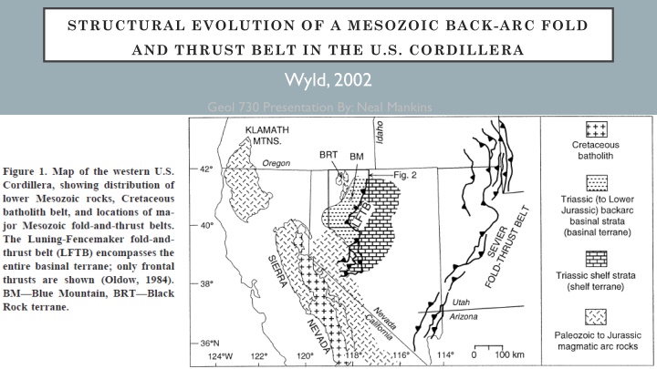
STRUCTURAL EVOLUTION OF A MESOZOIC BACK-ARC FOLD AND THRUST BELT IN THE U.S. CORDILLERA Wyld, 2002 Geol 730 Presentation By: Neal Mankins
METHOD PURPOSE Detailed mapping, stratigraphic & structural analysis of the Blue Mountains Integrating relationships from other studies (Focuses only on northern portion of the fold and thrust belt) To examine the stratigraphic and structural setting of the Blue Mountains, NV in order to understand the controls behind the Luning-Fencemaker fold and thrust belt
BACKGROUND Luning-Fencemaker fold & thrust belt Structural province between arc terranes to the West and interior continent to the east West Margin Bounded by paleozoic & Mesozoic magmatic arc rocks of the Black Rock terrane These arc rocks are thrust over coeval shelf strata East Margin Basinal-terrane strata are faulted over shelf rocks (middle-late Triassic) along the Fencemaker thrust
BLUE MOUNTAIN Geology Trbn (Triassic Blue Mtn. North) ~500m of phyllite with thick 1-5m bedded quartzites Trbc (Triassic Blue Mtn. Central) ~2800m of slate and phyllite Trbs (Triassic Blue Mtn. South) ~3400m pf phyllite with interbedded siltstone, sandstone, and limestone All of these units dip NW Trbn is faulted over Trbc & Trbs Trbc & Trbs are overturned (in the Blue Mtns.) based on age data & correlating similar stratigraphic sections in neighboring ranges (eg. Santa Rosa) Overturned units are located on the western limb of an overturned syncline who's hinge region is to the SE of Blue Mountain
CORRELATION WITH OTHER RANGES Southern Unit is similar to the Andorno Formation Central Unit similar to the Singas Formation Northern Unit is similar to the O Neill Formation
DEFORMATION 1 D1 Deformation & M1 Metamorphism (Jurassic) Low grade metamorphism <400 C (subgreenschist conditions) Pervasive structural grain within Triassic strata Fold axes from this event have a trend & plunge ~NE D1 structures are NE trending and NW dipping NW-SE shortening with tectonic transport to the SE
DEFORMATION 11 D2 Phase (Middle-Late Cretaceous) Open folds, crenulations, and spaced cleavage that cut older S1 fabrics Fold axis tend to be larger/ wider and generally plunge NW No metamorphic mineral growth is associated with the D2 event and is inferred to take place under more brittle conditions than D1
INTERPRETATION D1 Phase Minimum shortening found to be 55-75% based on 20 measurements of D1 folds Resulted in structural closing of the back-arc basin in the Jurassic Mesozoic shortening of ~400km Timing of D1 deformation is no precisely defined but deformed strata were intruded by a post tectonic pluton dated 165Ma placing the event ~late Early-Middle Jurassic D2 Phase Maximum NE-SW shortening found to be ~8-25% based on 10 measurements D2 deformation is thought to be related to the Sevier orogeny (farther to the East) Timing of this shortening event is defined only in the Santa Rosa range where late phase structures increase the strain and metamorphic grade in an intrusive stock dated 102Ma
TIME SPACE MODEL Interpretation 1. Late Triassic deep-marine sedimentation (~6700m) in basin between continental shelf and offshore volcanic arc 2. Deformation began in early-middle Jurassic in the northern basinal terrane, defined by NW-SE shortening 3. Tectonic quiescence along with exhumation and erosion spanned Late Jurassic Early Cretaceous 4. Deformation then continues again from Middle Late Cretaceous accompanied by relatively minor shortening related to the Sevier orogeny (further to the East) 5. Intrusive granitic stocks emplaced syn D2 deformation
TAKE HOME POINTS Luning-Fencemaker fold and thrust belt is a structural province between arc terranes to the West and interior continent to the east This ductile deformation event began in the early-mid Jurassic defined by folding and reverse thrusting accommodated by low grade metamorphism Mesozoic shortening of ~400km (55-75% NW-SE ) Led to closure of Triasssic deep- marine back-arc basin