UK Renal Registry 22nd Annual Report Data 2018 Analysis
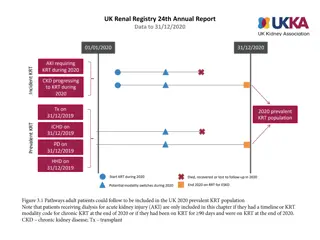
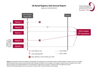
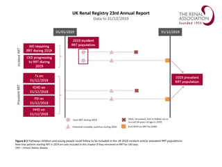
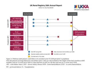
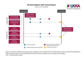
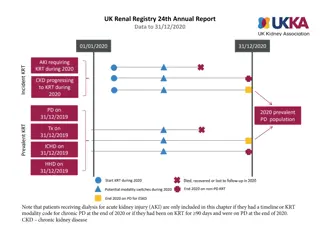
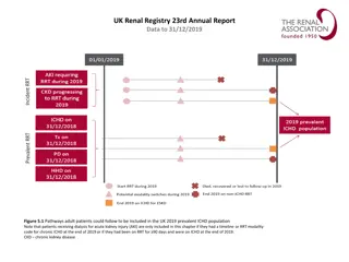
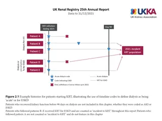
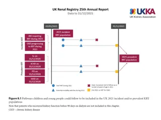
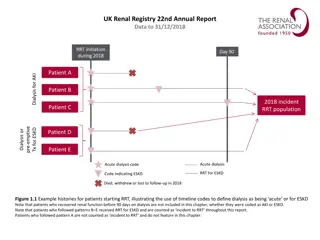
Adult pathways and prevalence rates in the UK RRT population from 2008 to 2018, including age group breakdowns and treatment modalities.

Download Presentation

Please find below an Image/Link to download the presentation.
The content on the website is provided AS IS for your information and personal use only. It may not be sold, licensed, or shared on other websites without obtaining consent from the author.If you encounter any issues during the download, it is possible that the publisher has removed the file from their server.
You are allowed to download the files provided on this website for personal or commercial use, subject to the condition that they are used lawfully. All files are the property of their respective owners.
The content on the website is provided AS IS for your information and personal use only. It may not be sold, licensed, or shared on other websites without obtaining consent from the author.
E N D
Presentation Transcript
Future directions in active satellite remote sensing for TE program and research priorities SassanSaatchi Amy Neuenschwander Ralph Dubayah Paul Siqueira
What is the future of active sensing of Vegetation Structure? INSAR and PolSAR missions underway or in development (ALOS2, DESDynI-Radar, BIOMASS). How do we take advantage of this data? Is there any support for spaceborne vegetation lidar? To what extent exiting suborbital active sensors can tackle big science questions?
Radar and Radar/Lidar Fusion Radar methods likely to dominate at global scale ALOS2, TANDEM-X,Tandem-L, DESDynI, BIOMASS Lack of fusion algorithms Fuse what with radar? ICESat? ICESat2? Airborne lidar surveys? Lack of systematic ecosystem structure data PolInSAR looming large Europeans strongly focused on polInSAR Temporal decorrelation major issue May become dominate technology for carbon/REDD above project scale
Space-based Lidar lack of space-based ecosystem structure focused lidar is a major obstacle to TE research ICESat2 was not designed as an ecosystem lidar, however, it will collect canopy height measurements globally but the efficacy is still uncertain. excellent understanding of requirements and technology Vegetation Canopy Lidar (1997) DESDynI Lidar (2008) GEDI Lidar (2012) GEDI mission (2012) is a Category1 mission presented to nasa for $150M GEDI would provide valuable 3d structure data over high biomass areas
action items Community (US) push for data policy relaxation for ESA and JAXA stop hugging trees and hug nasa program managers We need to provide nasa PMs with a collective voice for our needs (i.e. a space-based lidar mission) Suggest a mission/strategy workshop to prepare for DS2 to re-engage community for vegetation structure missions NEON also supports a space-based lidar utilize airborne lidar sensors to bridge the gap (LVIS on globalhawk) Could NASA support large airborne campaigns (regional flights) for TE projects